
Riparian Health Assessment Project
But the quality of water resources is affected by human and wildlife activity in the land along streams, lakes, rivers, ponds and wetlands, also known as riparian zones. Keeping these zones healthy is an important step in maintaining clean water for present and future use.
“We are fortunate to have the water resources that we do, and where necessary, the agricultural sector can take steps to protect them,” says Beth Densmore, 1st Vice President of the Nova Scotia Federation of Agriculture.
To help the agricultural sector understand how farms affect, and are affected by, the health of water supply areas, the NSFA worked with the town of Stewiacke on a pilot project to assess the riparian health of the St. Andrews River watershed in Colchester County. The project was funded under Agriculture and Agri-Food Canada’s Greencover Canada Technical Assistance Program.
The assessment was completed last year and focused on the watershed area located inside Stewiacke’s water supply boundary. It involved walking the riparian zones and scoring them based on standard criteria.
In a healthy system these zones are filters for nutrients and pollutants, provide shade and erosion protection, decrease flood severity, provide wildlife habitats, and remove carbon gas from the atmosphere. If this zone is degraded or removed, the system cannot provide all its beneficial functions.
The assessment found that of the 248 km of watercourses in the watershed, 223 km are healthy. Of the 25 km flagged as having problems, only 5.75 km were attributed to agricultural activities. The remaining problem areas were related to forestry activities, human impact and ATV use.
“Overall, the results are very good, especially as they apply to agriculture,” says Ms. Densmore “Producers are showing due diligence and some of the issues identified have already been addressed.”
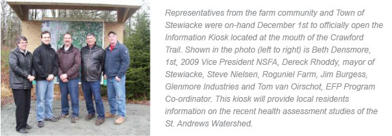
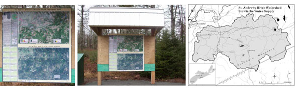
NSFA with the support of Applied Geomatics Research Group of the Nova Scotia Community College created a map from the data provided by the assessment. An information kiosk has been constructed and placed at the Crawford Trails parking lot in Stewiacke. The kiosk will identify the St. Andrews River watershed and provide information on maintaining its health.
Dereck Rhoddy, mayor of Stewiacke, stresses the importance of using the assessment to educate the community about what it means to protect the watershed.
“The purpose of the project was to raise awareness, get our community involved with their surroundings, and discuss how we can best manage protection of the watershed. It’s not to police or single out anyone,” says Rhoddy.
The data and knowledge gathered from the project will be used to look at ways of effectively conducting riparian health assessments in the future.